AROUND THE WORLD
Anti-submarine Indicator Loop stations in the United States
Drawing by Gerry Butler
One highly secret method of the past used to detect submarines relied on magnetic properties of submarines and surface vessels is the anti-submarine indicator loop. These loops of cable are laid on the ocean floor in shipping channels and when a submarine passes overhead an induced current is produced and this is detected on the galvanometers at the nearby shore station. Even if wiped or degaussed, submarines still have sufficient magnetism to produce a small current in a loop. This page indexes indicator loops in the USA during WW2.
 |
If you have any feedback please email me: Dr Richard Walding Research Fellow - School of Science Griffith University Brisbane, Australia Email: waldingr49@yahoo.com.au |
LINKS TO SOME OF MY LOOP PAGES:
BACKGROUND
What are Indicator Loops?
Submarines may be detected by many methods but one highly secret method of the past that relied on magnetic properties of submarines and surface vessels is the anti-submarine indicator loop. It relies on the production of an induced current in a stationery loop of wire when a magnet (in this case, a submarine) moves overhead. Even if wiped or degaussed, submarines still have sufficient magnetism to produce a small current in a loop. The technology was developed by the British Royal Navy in 1915. It was sent to various Commonwealth countries (Australia, Canada, New Zealand) for deployment. With the close technical co-operation between the Royal Navy and the US Navy, the indicator loop technology was enhanced for use in the US from about 1942 onwards.In the US, the control stations were known as 'loop receiving stations' and were a part of the Harbor Entrance Control Post (HECP). The first loop installation in the US was made at Cape Henry, Virginia in summer 1941, although hydrophones had been trialled at Fort Wright (Fishers Island, NY), Nahant (Boston) and Fort Story (Virginia) in 1918. Units (loops, hydrophones, heralds) were installed in practically every major and medium continential US harbor in the few months after August 1942 and by the end of 1942 were being shipped to the South Pacific. Underwater detection was installed in major and medium ports along the east and west coast of the US, the Aleutians, South Pacific, Central Pacific, France, Philippines, the Canal Zone (Bahia de Panama), Australia and South America. At the time of surrender, several units were ready in California to be shipped to Japan.
Today, more than 50 years after the war, many of the countries that still have US Navy loop cables are having them removed for a variety of reasons. One is that many ports are expanding or having their harbors dredged deeper to accommodate today’s larger ships. The cables are an obstacle to dredging operations and a potential hazard for ships anchoring. The other reason is their enormous scrap value. Most of the cables were constructed of copper, but with copper in such short supply during the war years, some were actually made of silver with the intent of reclaiming them after the war. However, very little salvage was ever done. Consortiums of private investors and government officials are now being formed to locate and remove these cables. (One of the companies performing this service is Resolve Marine Group in Port Everglades, FL. Resolve has been providing a variety of marine services to companies and government agencies in the U.S., Central and South America, and throughout the Caribbean for the past 20 years).
THE LOOP LOCATIONS
The following Harbor Entrance Control Posts all had loop receiving stations attached. The list below shows many of the HECPs and their naval unit codes. About 50 were set up by the United States Navy along the East and West Coasts of the US, The Aleutian Islands, South Pacific, North Africa, Sicily, Italy, SW Pacific, Central Pacific, France, Phillipines, Canal Zone and South America. Links will take you to separate pages for some of the stations I have details for.1st Naval District
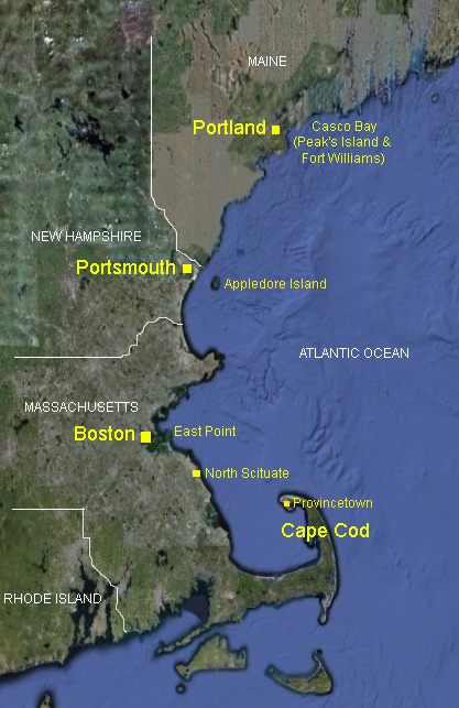
Casco Bay (Portland, Maine): 1A Bailey Island, 1B South Portland (Cape Elizabeth), 1F Peaks Island/Fort Williams
1C North Scituate (Fourth Cliff to Provincetown, Massachusetts); and Rhode Island (Massachusetts)
1D Nahant, East Point (Boston, Massachusetts)
1E Gloucester, 25 mi N of Boston (Massachusetts)
1G Portsmouth (Appledore Island, Maine
1H Fort Burnside
1I South Westport at Goosebury Neck (or Westport Point) - between Fort Rodman and US Naval Base at Newport (Massachusetts)
1X Argentia - Naval Base (Newfoundland) 3rd Naval District
Fort Tilden (New York) Harbor Entrance Control Post (HECP #2) Fort Hancock (New Jersey) HECP #1, Sandy Hook (& Spermacetti Cove). Combined webpage with Fort Tilden. Fort Wadsworth HECP, Staten Island, New York. Not a loop station but an administrative centre for HECP1 and 2. Fort Wright - Fishers Island (HECP) 4th Naval District
Fort Miles on Cape Henlopen near Lewes Delaware 6th Naval District
Ocracoke Naval Station (North Carolina) 15th Naval District
17th Naval District
Other HECP Locations
Many HECPs were established at critical harbors on the Atlantic and Pacific
coasts of the United States and it's territories:
District # ---- Station ----- Location ----------- Latitude - Longitude
1 -- Portland, ME -- Fort Williams -- (N43-37-15, W70-13-00)
1 -- Portsmouth, NH -- Ex-Coast Guard Station (Fort Stark, Battery Kirk) -- (N43-02-30, W 70-42-00)
1 -- Boston, MA -- Fort Dawes -- (N42-21-30, W57-30)
1 -- Newport, RI -- Beavertail -- (N41-27-00, W71-24-00)
3 -- Fishers Island -- Fort HG Wright -- (N41-15-22.8, W72-01-23.9)
3 -- Staten Island, NY -- Fort Wadsworth -- (N40-36-15, W74-03-22)
4 -- Delaware -- Cape Henlopen (Fort Miles) -- (N38-47-39, W75-05-32)
5 -- Norfolk, VA -- Just outside Fort Story -- (N36-55-48, W76-00-42)
6 -- Charleston, SC -- Fort Moultrie -- (N32-45-33, W79-51-31)
7 -- Key West, FL -- To be established
8 -- Santa Rosa Island, FL -- (Fort Pickens, Battery Worth) --
(N30-19-30, W87-17- 30)
8 -- Galveston, TX -- Fort Point (Fort San Jacinto) -- (N29-20-00,
W94-44-37)
10 -- San Juan, PR -- (Fort Brooke, El Morro) -- (N18-28, W66-07)
10 -- Vieques Sound (Roosevelt Roads), PR -- Punta Algodones
11 -- San Diego, CA -- (N32-40-19, W117-14-24)
11 -- San Pedro, CA -- Fort MacArthur (Battery Leary and Merriam) (N33-42-42, W118-17- 32)
12 -- San Francisco, CA -- Fort Winfield Scott (Dynamite Battery) --
(N37-48-08.3, W122-28- 32.7)
13 -- Columbia River -- Fort Stevens (Battery Mishler) -- (To be
established)
13 -- Puget Sound Area, WA -- Fort Worden -- (N48-08-30, W122-46-00)
14 -- Pearl Harbor, HI -- NavyYard Pearl Harbor -- (N21-21-11.9, W157-57-26.2)
15 -- Cristobal, Panama Canal Zone (Atlantic Side) -- Fort Sherman -- (N9-22-00,
W79-57-00)
15 -- Balboa, Panama Canal Zone (Pacific Side) -- Fort Amador -- (N8-55-00,
W7931-00)
16 -- Manila Bay, Corregidor -- Fort Mills -- (N14-22-59, E120-34-23)
Note 1: Lat-Long coordinates are provided for plotting purposes, to locate
sites with GPS navigation units, and to utilize the Microsoft Terraserver
Satellite photograph database.
Note 2: Comments in italics added by author to reflect actual locations.
If you have any feedback on this webpage, including photos or details, please email me -
Dr Richard Walding - at waldingr49@yahoo.com.au